The Economic Crisis of the Gulf of Riga: An Ecological Deadlock
The Gulf of Riga has shifted from a strategic economic asset to a biological liability. Today, the bay acts as a massive "internal reactor," where decades of accumulated nutrients are fueling an ecological decline that directly impacts the budgets of Latvia and Estonia.
1. Impact on Tourism and the Resort Economy
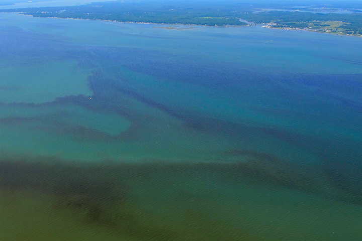
The "pearls" of the Baltic, such as Jurmala and Pärnu, are facing a systemic threat. Seasonal cyanobacterial blooms—driven by rising temperatures—frequently lead to swimming bans and the pervasive smell of decomposing organic matter.
- Economic Toll: Peak-season tourism revenue can drop by 15–25% during heavy bloom years.
- Reputational Risk: Frequent "red flags" on beaches damage the long-term brand of the region, shifting high-end tourism toward more stable climates.
2. The Fishery Crisis and "Dead Zones"
Eutrophication has led to chronic hypoxia (oxygen depletion) in the deeper layers of the bay.
- Habitat Loss: The expansion of "dead zones" destroys the benthic (bottom) feed base, critical for cod and juvenile fish.
- Industry at Risk: While herring and sprat remain stable for now, the degradation of spawning grounds threatens an industry worth hundreds of millions of euros. Without intervention, rising water temperatures will accelerate the collapse of traditional fish stocks within the next decade.

3. Water Infrastructure and Public Health
The bay’s degradation places a direct financial burden on municipal budgets, particularly in Riga.
- Filtration Costs: The presence of cyanotoxins in the Daugava requires increasingly complex and expensive chemical filtration systems to ensure safe drinking water.
- Infrastructure Strain: Combined sewer overflows (CSOs) during heavy rains continue to bypass treatment plants, creating a cycle of pollution that leads to heightened risks of waterborne diseases and increased healthcare expenditures.
4. The "Internal Loading" Trap
Despite billions of euros invested in wastewater treatment and agricultural runoff limits, the bay is rotting "from within."
- Legacy Phosphorus: Phosphorus accumulated in bottom sediments over the last 50 years is released back into the water column during every hypoxic event.
- The Dead End: Current mitigation strategies are failing to address this "internal load," meaning the bay continues to self-pollinate with nutrients even as external pollution decreases.
Conclusion: The Gulf of Riga is no longer a self-sustaining ecosystem; it is a system in debt. Without shifting focus from "reducing runoff" to "active seabed remediation," the region faces a permanent loss of ecosystem services and a multi-billion euro long-term economic drain.
Method of Thermogravitational Destruction of Stratification and Supply of Bottom Layers with Oxygen
Each of the physical processes underlying the proposed method has been independently studied, described in scientific literature, and confirmed by natural observations. The novelty of the method lies in their engineering integration into a single passive system that does not require external energy sources.
The task is not to prove physical principles or repeat frequently conducted experiments, but to solve specific engineering problems that determine the system's operability in field conditions.
1. Problem: Summer Stratification and Hypoxia
Summer thermal stratification is a universal process in lakes and semi-enclosed seas of temperate climates. Solar heating creates a stable thermocline, separating the warm epilimnion from the cold hypolimnion. Typically, in shallow waters, the thermocline forms at a depth of 8–15 m with a temperature difference of 8–10°C between layers.
The thermocline effectively blocks vertical oxygen transport. Anoxia develops in the hypolimnion: bottom sediments transition to a reducing regime, releasing accumulated phosphorus (Mortimer mechanism), hydrogen sulfide, and other reduced compounds. Phosphorus fuels toxic cyanobacterial blooms in the epilimnion. Fish are forced into a thin, overheated surface layer, benthos dies, and the water body's bioproductivity drops catastrophically.
Phosphorus accumulated in bottom sediments over decades continues to be released into the water during every summer stagnation, regardless of measures to limit external runoff. In autumn, when stratification breaks down, mass gas releases and fish kills occur. The only way to break this cycle is to provide oxygen to the bottom layer during the stratification period.
Local impact within a limited zone in an open water body is unstable due to horizontal mixing and rapid erosion of the effect. The minimum impact area must encompass the entire territory of the water body zones located below the thermocline, which at first glance makes the task seem energetically impossible.
Mortimer, C.H. (1941). The exchange of dissolved substances between mud and water in lakes. J. Ecology, 29, 280–329.
2. Physical Mechanism: Chain of Processes
The method of thermogravitational penetration of stratified layers is based on the initiation of a self-sustaining cascade of hydrodynamic processes. The energy source is the potential energy of the stratified water body—energy already stored in the density and temperature differences of the layers, which many times exceeds the thermal contribution of the trigger.
Step 1. Initiation: Cold Plume
A polyethylene film with a white top and black bottom, featuring 0.1 mm micro-perforations, is placed on the water surface. Its dimensions will be selected based on the water body's conditions; we tentatively estimate it at 100–200 feet. The white surface reflects solar radiation, while the surrounding water heats up. The water under the platform remains 1–3°C cooler. The surrounding warm water, being lighter, displaces it downward. A descending density plume is formed.
A natural analog is differential coastal heating: shallow zones heat up more than the deep part of a lake, giving rise to horizontal density currents and convective plumes. Our method reproduces this mechanism artificially in a specified location.
Monismith, S.G., Imberger, J. & Morison, M.L. (1990). Convective motions in the sidearm of a small reservoir. Limnol. Oceanogr., 35(8), 1676–1702.
Step 2. Depression and Radial Spreading
The plume reaches the thermocline at a depth of 8–12 m and creates a depression zone in it. Upon reaching the level of neutral buoyancy, the water spreads radially outward as an intrusion—a horizontal density current. For example, water at ~20°C ends up in the depression zone, while nearby at the same depth, the thermocline water is ~17°C. The density difference (delta rho) of approx. 0.6 kg/m3 creates a horizontal pressure gradient of approx. 6 Pa/m: cold thermocline water flows toward the center at a speed of approx. 10–15 cm/s, while warm water spreads outward.
Akiyama, J. & Stefan, H.G. (1984). Plunging flow into a reservoir: theory. J. Hydraulic Eng., 110(4), 484–499.

Step 3. Kelvin-Helmholtz Instability and Turbulent Mixing
A velocity shear forms at the boundary of the countercurrents. The Richardson number Ri = (g * dr/r * dz) / (du)^2 at flow velocities du approx. 0.25–0.30 m/s is approx. 0.09 — three times lower than the critical value of 0.25. The flow is unconditionally unstable. Kelvin-Helmholtz Instability (KHI) develops: vortex structures twist and mix the layer interface. KHI is the primary mechanism of vertical turbulent exchange in stratified water bodies — a fact confirmed many times in both laboratory and field observations.
Thorpe, S.A. (1971). Experiments on the instability of stratified shear flows. J. Fluid Mech., 46(2), 299–319. // Saggio, A. & Imberger, J. (1998). Internal wave weather in a stratified lake. Limnol. Oceanogr., 43(8), 1780–1795.
Step 4. Positive Feedback
KHI provides vertical transport of cold water from the thermocline upward within the descending water column. The water under the platform cools down, its density increases, and the descent accelerates. The system reaches a quasi-stationary self-sustaining mode. The platform serves only as a trigger: the further process is powered by the potential energy of the released thermal gradient of the entire water body.
Step 5. Radial Propagation of the Instability Front
The cold thermocline water does not move toward the center in a continuous front, but in jets, creating local mass deficits—caverns—in the thermocline. In each cavern, a shear flow forms again; if the Ri < 0.25 condition is met once more, KHI arises again. The process reproduces itself, spreading radially as a cascading multiplication of shear instability zones, powered by the potential energy of the water body throughout its propagation path.
Heaps, N.S. (1966). Two-dimensional numerical sea models. Phil. Trans. R. Soc. Lond. A, 265, 93–137. // Lorenzen, M.W. & Fast, A.W. (1977). A guide to aeration/circulation techniques for lake management. EPA-600/3-77-004.
Step 6. Direct Oxygen Supply
Simultaneously, a portion of the oxygen-saturated vertical surface flow does not spread radially; instead, it sinks and mixes with the deep layer beneath the platform, providing a direct supply of oxygen to the deep layer.
3. Implications for the Ecosystem
- Bottom Layer Oxygen Saturation: Restoration of vertical circulation ensures a slow downward flow of oxygen-saturated water. This transport is also facilitated by convective mixing due to the resulting instability and flows from the platforms. Toxic gases are oxidized directly in the hypolimnion without reaching the surface. The risk of explosive ascent, typical of mechanical mixing, is eliminated due to the gradual nature of the process.
- Phosphorus Lock: Oxygen reaching the bottom sediments converts Fe(II) to Fe(III), which forms insoluble complexes with phosphates. Internal phosphorus loading stops. Algae are deprived of their primary source of nutrients, blooms fade, and water transparency is restored.
- Bioproductivity: Fish gain access to the entire water column. Benthos recovers on the bottom. The summer "bottleneck" — the concentration of the entire population in a thin surface layer, where predators destroy fry and fish die from overheating and disease — is eliminated. The water body's bioproductivity increases dramatically.
4. Preventive Strategy: Impact from May
If platforms are deployed in May, when the thermocline is just forming and has a thickness of 1–2 m, the energy barrier for its destruction is an order of magnitude lower than that of an established summer thermocline. Regular destruction of the young layer prevents it from strengthening. Instead of fighting established stratification, a strategy of preventing its occurrence is implemented — a fundamentally more economical approach.
5. Engineering Challenges
- Perforation: 0.1 mm diameter holes must allow steam to escape from the inside (steam pressure under the film is higher than atmospheric due to the black bottom heating to +50–60°C) and simultaneously prevent water from leaking out. Capillary pressure to hold water in a 0.1 mm hole is ~1.4 kPa — this is physically achievable but requires precise control of the diameter and shape of the holes.
- Adhesion to Water and Storm Stability: The film is held on the surface by surface tension and its own elasticity. The water surface is a reliable foundation: the film follows the wave profile, has no rigid frame. Wind presses the film to the water (Bernoulli effect) rather than tearing it off.
- Anchoring: A floating anchor (parachute) at a depth of 10–15 m slows drift by utilizing the inertia of slower deep-water masses. With typical currents of 2–4 cm/s at a depth of 10 m, the platform will shift 2–6 km/day.
- Winding, Transportation, and Washing: Transportation is carried out only in a rolled state. A specialized small vessel pulls up alongside the edge of the film: several dozen motors wind the film onto floats. Combined washing and duct blowing are performed during the winding process.
- Reversibility: The experimental system is inherently reversible: removing the platform leads to the decay of the initiated processes within the time scales characteristic of the water body.
6. Necessity of Partnership
Conducting a pilot experiment is impossible without the active participation of local authorities, ecologists, and scientists.
- Permits and Water Area: Deployment of platforms requires coordination with maritime authorities, port services, and environmental agencies.
- Business Partnership: Platforms provide fish with shade and act as natural attractors. Fishing under such platforms will be extremely successful. We seek to involve the business community to manage these new opportunities.
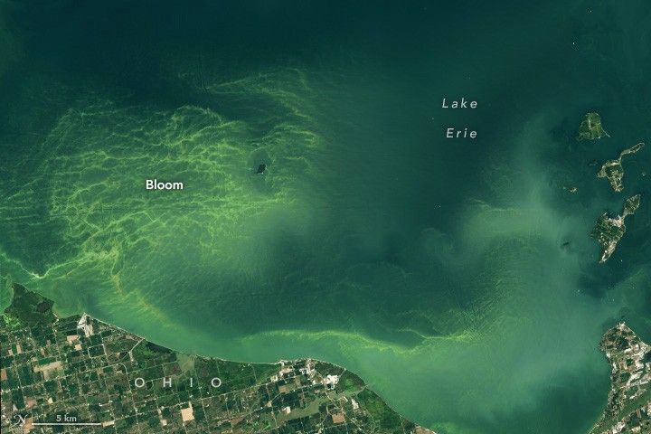
- Site Selection: We are considering locations including the Gulf of Riga (Latvia, Estonia), Lake Erie, and the Gulf of Mexico (USA).
- Measurement and Verification: Evaluating the platform's influence requires measuring infrastructure: thermistor chains, ADCPs, and oxygen probes in partnership with local scientific organizations.
Contact: info@savegulfstream.org |